On Feb. 11th 2013, NASA launched its eighth Earth-observation satellite as part of the Landsat Data Continuity Mission. Landsat 8 will join two other Landsat satellites still in orbit, although one of those was recently decommissioned (Landsat 5). The satellite is in a healthy orbit and NASA is receiving its telemetry, however no acquired images have been released at this time. this new satellite will directly affect how we continue to monitor the Earth from space. Having this direct overlap of satellites will allow us in education and faculty/student research efforts to investigate temporal changes in the environment, monitor disasters and human impact for years to come. We are very excited to see these new images. I’m at the edge of my seat in anticipation.
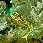
The Landsat Program is a series of Earth-observing satellite missions jointly managed by NASA and the U.S. Geological Survey since 1972. This science, known as remote sensing, has matured with the Landsat Program. currently there are more than 3 million Landsat images in the National Satellite Land Remote Sensing Data Archive. The lifespan of these satellites vary. Often this time limit is predetermined, however not predictable. Landsat 5 has just set a Guinness World Record for ‘Longest Operating Earth Observation Satellite’. Launched in 1984, it is still acquiring images of Earth. This little satellite is said to have saved the Landsat program with the unexpected loss of Landsat 6 in 1996 and the yet unlaunched Landsat 7 (1999) preventing the data gap. After a long over do wait, we

NASA: “The Landsat Data Continuity Mission (LDCM) is the future of Landsat satellites. It will continue to obtain valuable data and imagery to be used in agriculture, education, business, science, and government. The Landsat Program provides repetitive acquisition of high resolution multispectral data of the Earth’s surface on a global basis. The data from the Landsat spacecraft constitute the longest record of the Earth’s continental surfaces as seen from space. It is a record unmatched in quality, detail, coverage, and value.”
Sensors on the new satellite
Operational Land Imager (OLI)
- Nine spectral bands, including a pan band:
- Band 1 Visible (0.433 – 0.453 µm) 30 m
- Band 2 Visible (0.450 – 0.515 µm) 30 m
- Band 3 Visible (0.525 – 0.600 µm) 30 m
- Band 4 Near-Infrared (0.630 – 0.680 µm) 30 m
- Band 5 Near-Infrared (0.845 – 0.885 µm) 30 m
- Band 6 SWIR 1(1.560 – 1.660 µm) 30 m
- Band 7 SWIR 2 (2.100 – 2.300 µm) 30 m
- Band 8 Panchromatic (PAN) (0.500 – 0.680 µm) 15 m
- Band 9 Cirrus (1.360 – 1.390 µm) 30 m
Thermal Infrared Sensor (TIRS)
- Two spectral bands:
- Band 10 TIRS 1 (10.3 – 11.3 µm) 100 m
- Band 11 TIRS 2 (11.5 – 12.5 µm) 100 m
Landsat 8 has similar band combinations as Landsat 5 & 7 to ensure continuity. But has a few additions for enhanced analysis. I will continue to Keep the CC community apprised of the situation in the months to come.
Links:
landsat data continuity mission
Watch live as Landsat data is collected