Toby Minear ’98
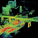
Three CC grads had a whirlwind encounter during the immediate aftermath of Hurricane Isaac, which struck the northern Gulf Coast in late August. I had been asked to join a pilot project studying the flooding effects of the hurricane through my work using Terrestrial LiDAR (T-LiDAR) as a post-doc at the United States Geological Survey in California. T-LiDAR is a distance-measuring laser combined with precise angle encoders to measure a fully 3D map, or “point-cloud,” of the nearby area. T-LiDAR had been used successfully for investigating levee failures in New Orleans during Hurricanes Katrina and Rita, and the technology had shown potential for mapping flooding effects in 3D.

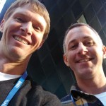
Toby Minear. left. and Ryan Ewing at the fall American Geophysical Union meeting.
With only 12 hours to prepare, including mobilizing a large amount of science equipment from California before the hurricane made landfall, I called Ryan Ewing ’98 for help. Ryan managed to escape his busy schedule as an assistant professor at the University of Alabama. No less of a feat, Ryan convinced his department chair to let him borrow the brand-new T-LiDAR instrument and head into a hurricane. Ryan hopped into his car for a harrowing trip to New Orleans through flooded roads, flocks of insurance adjustors, and long lines of power utility trucks all converging on the city. Within several hours of Hurricane Isaac’s landfall, a large percentage of parishes in the area already were without power.
Ryan and I rendezvoused in East New Orleans and managed to find a tiny room at one of the only hotels with power. (Despite initial misgivings, we calmed down once we realized that the room was more spacious than many we had shared during block breaks, and with far fewer people to share it with.) After T-LiDAR scanning one site the evening the equipment arrived, I processed the data and sent it off to the USGS press corps for inclusion in a possible news story. In the morning, a surprising press release was sent out, including input and quotes from Marcia McNutt ’73, director of the United States Geological Survey. Ryan’s response was, “Wow, I thought it was important but I didn’t realize it was that important,” followed quickly by, “Do you think she knows we went to CC?”

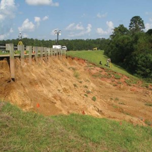
Photograph of landslide at Tangipahoa Dam, Mississippi, with Ryan Ewing ’98 for scale.
During the next several days, Ryan and I used T-LiDAR to scan a number of flood-damaged sites, including marinas, levees, dams, neighborhoods, and bridges. Luckily, few people were injured in Hurricane Isaac; however, many in the outlying parishes suffered extensive flooding damage, and with power and AC out of commission, the heat index approached 110 degrees for several days. At one of the sites, Tangipahoa Dam in Mississippi, landslides caused by the heavy rainfall of Hurricane Isaac prompted the evacuation of tens of thousands of residents downstream. Our T-LiDAR work monitoring the landslides at the dam resulted in another press release, which also included quotes from USGS Director McNutt. McNutt said later about the experience, “When you have an important job to do in an emergency situation, requiring the latest in technology, who else would you call in but a crack CC team?”
