“The known is finite, the unknown infinite; intellectually we stand on an islet in the midst of an illimitable ocean of inexplicability. Our business in every generation is to reclaim a little more land.” -T.H. Huxley

![]()
| About CC | Academics | Admission & Financial Aid | Athletics | Directory | News & Events | Support CC | Tutt Library | Colorado College |
“The known is finite, the unknown infinite; intellectually we stand on an islet in the midst of an illimitable ocean of inexplicability. Our business in every generation is to reclaim a little more land.” -T.H. Huxley
![]()

Lake Surprise, Mountainside, NJ. Photo Credit: Santos (_atrographic on Flickr)
In class, we have moved on from astronomy and are now discussing geology and its effects on life. Since geology is so important to not only the formation of life, but also its continuation, I thought it might be interesting to investigate the geology that affects me the most: the geology of my hometown.

Moutainside, NJ. Photo Credit: Sperling’s Best Places
Mountainside, New Jersey is surprisingly full of interesting geological features. Ravines, springs, highland swamps, mineral and rock deposits, a quarry! But the most prominent feature would have to be the one the borough is named for, the mountain.
The “mountain” in Mountainside is no mountain by Colorado standards. In fact, it would probably only be considered a sorry hill, but to me it makes all the difference. Mountainside is, in fact, located on the “side” of said mountain. My house is situated at the top of the ridge, across the street from the Watchung Reservation, a forest preserve. The ridge is the first major increase in elevation from the coast, so from merely two houses down from me, you can see the entire New York City skyline and sometimes, the ocean (especially in the winter)!

The Sierra Trail, Watchung Reservation. Photo Credit: County of Union, NJ
The mountain is one of 3 ridges that make up the Watchung Mountains (from the Lenape Wach Unks, or “high hills”). Being the furthest east, it is denoted as the 1st Watchung Mountain. I live on a southern subsection that is part of the Newark Mountains near the Hobart Gap.

The Watchungs. I live just southeast of Springfield. Photo credit: lithium6ion
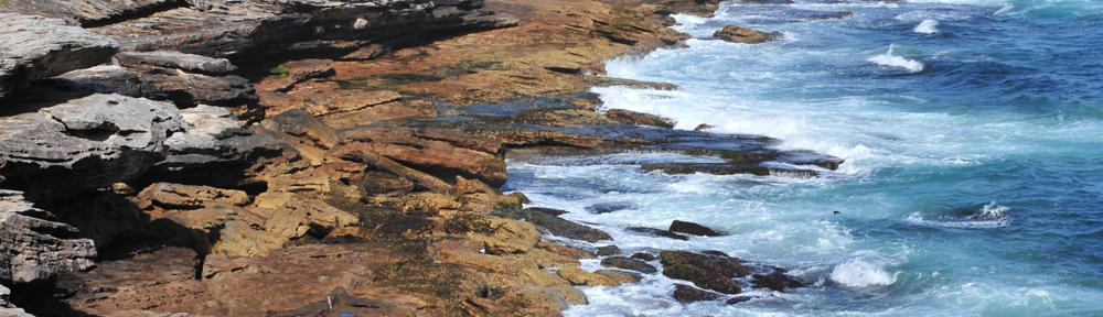
The Watchung mountains are of volcanic origin and run for 40 miles roughly north to south in north central New Jersey. They can range from 400 to almost 900 feet in height (above the sea level surroundings). They were formed in a giant rift valley 200 million years ago when the supercontinent, Pangea, broke apart. They are made of Watchung basalt and Jurassic sedimentary rock. They were worn down by erosion and during the last ice age, shaped by glaciers. The third mountain encloses the Great Swamp, the remnants of Glacial Lake Passaic.

The Great Swamp National Refuge. Photo Credit: Flat Rock
They are home to many different minerals, rare traprock, and endangered ecosystems and flora and fauna. Dinosaurs have roamed, Native Americans thrived, Washington even used them to strategically place encampments during the Revolution! But to me, they are home.

The Watchung Stables, where I learned to ride growing up. It was originally created as a Nike Missile Base Control Station during the Cold Way and utilized the Watchungs’ strategic position to protect New York City. Photo credit: Gone Hikin’
Sources:
http://en.wikipedia.org/wiki/Watchung_Mountains
http://www.infoplease.com/encyclopedia/us/watchung-mountains.html

![]()
Off of the coast of my hometown, Ventura, in southern California, lies the Channel Islands Archipelago. The archipelago contains eight different islands, five of which are part of Channel Islands National Park, split into the Northern Islands and Southern Islands. The Northern Islands include Anacapa, San Miguel, Santa Cruz, and Santa Rosa islands, extending from Santa Barbara to Ventura counties. The Southern Islands are composed of San Clemente, San Nicolas, Santa Barbara, and Santa Catalina. The Southern Islands stretch down to Los Angeles county.
The islands geologic history dates back 100 million years and is a direct result of plate tectonics in the area. Until roughly 30 million years ago, the location of the Channel islands was the location of two tectonic plates, the Farallon Plate and the North American Plate. As the two plate collided, they were destroyed over time by subduction. A marine basin formed and over millions of years, the sediment that washed off the coast collected on the basin, forming the early base for the islands. Once the Farallon Plate was completely gone, the Pacific Plate moved in and began to rub against the North American Plate. This created the famous San Andreas fault in California. The orientation and size of the islands is a direct result of the Pacific Plate coming into contact with the North American Plate. The entire above surface portion of the islands has risen within the last 5 million years.

A map of the Channel Islands, showing both the Northern and Southern island groups. Source: Wikipedia.
Some of the islands are a result of volcanic activity that took place underwater. Anacapa and Santa Barbara islands, for example, are composed almost entirely of volcanic rock. Evidence of this comes in the form of ‘pillow lava’, or lava that originated underwater. Fossilized shells of oysters and other marine species can be found among the pillow lava. The volcanic activity responsible occurred between 19 to 15 million years ago, a period in which lava covered a large portion of the area containing the Northern Channel Islands. Evidence shows that the original islands created from these eruptions and outpouring were significantly larger than the islands that exist now. Some claims even state peaks as high as 5,000 feet. ‘Volcanic bombs’ have been discovered at nearby known volcanic regions, the Conejo Volcanics and Santa Rosa Island Volcanics, supporting the idea of much larger islands. These islands, however, likely eroded very soon after volcanic activity stopped on the islands, leaving the islands we see today.
The rocks on the Northern islands are mainly composed of sedimentary rocks made of shale and sandstone, remnants of the era when the islands were formed. The existence of round pieces of rhyolite in the sedimentary layers indicates that the islands originated near San Diego, and have since rotated 90-100 degrees since.
Information obtained from Wikipedia and the official Channel Islands page at the National Park service website.

![]()
Two weeks down, and still no signs of alien life. However, we’re still holding strong. We’ve recently shifted our focus in class to geology, taking a look at the conditions on Earth that have made life possible, and could potentially do so in other solar systems. For this post, we were asked to research significant geological features near our home towns. Little does everyone know, my home town is located in the middle of such a significant feature. Or should I say, on the bottom of one.

Sometime around 13,000 years ago, near the end of the last ice age, Missoula, Montana would actually have rested on the floor a 2,000 feet deep glacial lake. In the picture above (which includes my neighborhood, just near the end of the left-most bridge), the water would have risen to about three quarters of the way between that small white “M” on the mountainside and the summit. The top of the mountain would have been just a tiny island in the middle of a lake that was bigger than Erie and Ontario combined.
Glacial Lake Missoula was formed when the Corellian Ice Sheet encroached southward between modern-day Montana and Idaho, damming the Clark Fork river (as seen above). The resulting build-up of water flooded the valleys of Western Montana for 200 miles eastward.

However, the story doesn’t end there. Sometime after its formation, the water level rose so high that it began to strain the ice dam. Eventually, the 2,500 foot tall wall of ice gave way, and a rush of water with a force 60 times greater than that of the Amazon burst out into eastern Idaho. Travelling at speeds close to 50 or 60 miles per hour flooded out across Idaho and beyond, tearing apart mountains and carving canyons through Western Washington (forming the “Scablands” seen there today), and carrying car-sized boulders some 500 miles.
Evidence of this monumental body of water can still be seen today. Apart from the scablands and the Columbia River Gorge, researchers have discovered 13,000 year old ripple marks carved into the valley floors of Montana, products of underwater sediment.

Also, similar marks can be seen on Mount Jumbo, which can be seen from the back door of my house…

… and other sedimentary formations in the surrounding hills point towards an ancient, massive body of water.

http://www.glaciallakemissoula.org/
http://www.nps.gov/history/history/online_books/geology/publications/inf/72-2/images/fig12.jpg
http://en.wikipedia.org/wiki/File:GLMsed.jpg

![]()

In my hometown, the beautiful city of Hong Kong, lies a very special rock formation: The Lion’s Rock. But to my young self, growing up around Walt Disney’s Lion King, it was the Pride Rock. The rock formation dates back to the Upper Jurassic Period, roughly 140 million years ago. Like most of the rocks in Hong Kong, the Lion’s Rock is mostly made of Volcanic granite. It is made of This is a major attraction in Hong Kong and has great significance in Hong Kong’s history. Before the Lion Rock Tunnel was built (a tunnel through the mountain, to get to the other side of the town), people would hike the lion’s trail to deliver messages and food every day.


Sitting at the entrance of the Lion ‘s Rock tunnel is a smaller, natural rock statue, called the Amah Rock. “Amah”, in Cantonese, means mother. The rock loosely resembles a woman with a child on her back, facing the sea. The legend says that a woman would bring her son to this hilltop, watching over shore, awaiting the arrival of her husband, a fisherman at sea. Little did she know that her husband had already drowned. Days go by and months, and yet the woman does not give up, till the day she passes. As a reward for her loyalty, the Goddess of the Sea made her body into a statue so her spirit can reunite with her husband up in the heavens. The Amah Rock is often a place where people (single and couples) make wishes. It is also a symbol of loyalty and faith.
Both the Lion’s Rock and Amah Rock have benefitted Hong Kong people significantly, though one practically and the other spiritually. The natural rock formations mostly likely formed over time due to erosion. But the structure of these formations and the resemblance they possess are stunning noticeable. Whether civilization emerged around these rocks as a result is certainly an interesting question. If not, it surely is a spectacular coincidence.
Reference:
http://www.afcd.gov.hk/english/country/cou_vis/cou_vis_cou/cou_vis_cou_lr/cou_vis_cou_lr.html
http://travel.cnn.com/hong-kong/life/top-10-parks-and-nature-reserves-hong-kong-615373
http://en.wikipedia.org/wiki/Lion_Rock

![]()

Indian Wells Beach, Amagansett, NY
Home sweet home. Amagansett, a small – and I mean small – seaside-town on the southeastern tip of Long Island. While once revered for its placement on the list of “top five eighteenth-century whaling villages that eighteenth-century whalers didn’t know existed”, it is perhaps best known now as a member of a collection of small towns in the area which are referred to together as “The Hamptons”. Every summer, the first week of July through Labor Day to be more precise, my hometown is invaded by vacationers from all over New York and the rest of the east coast. The beaches fill up to the point where large groups of locals picket the parking lots, demanding the young tourists leave and take their “OBEY” snapbacks with them; The roads become almost not worth using from the hours of 11AM-6PM due to the traffic. The vacationers thoroughly enjoy their stay in the quaint villages, in their quaint, modern, beachfront, wooden boxes, and walking down the quaint sidewalks that are slowly erecting more Ralph Lauren, Chanel, and Prada stores by the week.
We locals treasure the summer for the weather, but loathe it equally for fear of the throngs. The most troubling issue in being a local and dealing with the summer visitors may be dealing with the occasional look of shock on their faces in being told that you actually live in Amagansett year-round. Yes, that is correct, this town was not just built to host your golf-outings and sunglass shopping. Ok, so some of the town is built for that, and it would probably burn down and be ransacked by Rhode Island if it weren’t for the money that you and your sunburned children spend on sunscreen every summer, but we do other things too. Like surf. Or fish. Or… boat? Not to mention some of our geology:

All typing and painting done by yours truly
When I said Amagansett is on the tip of Long Island, that wasn’t 100% correct. It’s more like Tip Jr. Almost there, so so close, but just one town over. Long Island has a literal tip, with a lighthouse on it and everything. The tip, the lighthouse, and the town built around the both of them, is called Montauk. Montauk, by its own accord, isn’t technically part of the Hamptons, and it’ll probably always stay that way, forever stuck in its, deep-rooted, fishing/clamming-town culture. The most popular souvenir purchased by summer Hamptonites is without a doubt the “THE END” t-shirts sold all over Montauk. Montauk is without a doubt the end now, but it was not always. In fact, for thousands of years following the last ice age, Amagansett was the tip of Long Island.
Long Island was formed through a series of so-called “depositional events” from the Wisconsin Glaciation, a massive sheet of ice that covered a large portion of northern-northern North America. Canada essentially.

Wisconsin Glaciation
It was the debris from the shifting ice sheet that was responsible for forming the early separate land masses that, due to the erosional processes operating in the early Holocene period, eventually formed together and gave birth to Long Island: Capacity 99.5%. It was close, but not yet fully realized.
It must of looked something like this:

That, right there, that’s science
When glaciers shift, consolidations of this glacial debris, called moraines, are left behind on their pathways. However, as it is easily imagined, these ice sheets did not have sediment covering the entirety of their surface areas. These moraines were deposited with gaps in between. These sections, or perhaps just portions consisting of significantly less debris, of the ice-sheets left dips in between higher rising coasts. The sea level was much lower than it is today, and, as such, there was a period during which rather than the dip being filled with nothing but water, there could plausibly have been a strip of much lower-laying land connecting Amagansett and Montauk. This strip could not have lasted for long. As the glaciers began to melt, and the sea levels rapidly rose, that dip was quickly swallowed by the waters. Even if that strip had existed, eventually it would have been entirely submerged in water. So technically, for a time, Amagansett was the tip of Long Island.
So what you got on that, parking-spot thieves?
If the sea had never risen, the dip may have filled in on its own eventually due to erosion processes driven by the wind. But now, with the dip entirely filled with ice-cube melt off, the eroding process would be driven by the water. Eroding sentiments driven by currents from both Gardiner’s Bay – referring to Gardiner’s Island: an island that has been privately owned by the same family for more than one-hundred years, an island, fitting with some of the Long Island “old-money” stereotypes, about the size of four square city blocks – and the Atlantic Ocean, eventually filled in this gap, leaving unique formations (e.g. sand splits, bay mouths) in the land mass that now bridged the faraway coasts of Amagansett, known colloquially amongst the unfortunately-ill-famed, Amagansett born, Ishmael-protege whalers, as “THE END”, and Montauk, a place where people liked to fish I guess.
In present day, this strip is called Napeague, derived from a Montaukett word. The Montauketts were a Native American tribe that resided on the eastern outskirts of Long Island, before the pats sailed over. They were known for walking incredibly long distances, miles and miles of sand dune, to get from tribe to tribe, and also for balling really hard.
The word that gives Napeague its derivation meant “land overflowed by the sea”. So obviously, as far as small strips of land go, Napeague is a pretty interesting place with a really awesome name, and, by association, that proves that Amagansett, and the Hamptons in general, are forever interesting and awesome. And yes, it is possible to live in the area during the winters, no we don’t fear tsunamis, yes there are too many deer, but despite what you might have heard there are no bears or land-sharks. So there’s no need for that look of surprise on your face.
But Napeague is still just basically 11.5 miles of stuff no one really cares about.
Works Consulted:
http://dspace.sunyconnect.suny.edu/bitstream/handle/1951/47770/DUBECK00.pdf?sequence=1
http://people.hofstra.edu/J_B_Bennington/research/long_island/li.html
http://www.zonu.com/fullsize-en/2009-11-09-10972/Wisconsin-glaciation.html

![]()

Red Rocks Park
If I had to choose one activity that gives Red Rocks Park in South Burlington, VT its fame, it would be cliff jumping, with cliffs ranging from 5 to 76 feet and deep water to land in. And undoubtedly, speaking from personal experience, that is the main draw to this beautiful natural area on Lake Champlain. But most people don’t take much time to stop and admire the amazing stratified quartize jutting diagonally out of the water that makes up this cliff jumping “funpark”. Furthermore, few people stop and wonder how that amazing rock actually got there. This is Vermont we are talking about after all, and rock formations like Red Rocks is a pretty rare occurrence for most of the state.
To answer the question of how Red Rocks came to be, first we have to look at plate tectonics and an early, developing Earth. Roughly 500 million years ago, Vermont was near the equator and South Burlington was part of a sand beach on the coast of the Lapetus Ocean, a precursor to the Atlantic. The sand on this beach gradually deposited and solidified into the strata of sandstone that would eventually make up Red Rocks. Then, roughly 450 million years ago, there was a collision between the coast of Vermont and a small island chain. This collision caused the Green Mountains that the state is known for to form, as well as the creation of the current quartzite cliffs due to the heat and pressure of the collision with the layers of sandstone. As continents continued to move and shape, mile-deep glaciers formed over what is now Vermont and Lake Champlain. Even when these finally receded though (roughly 13,000 years ago), Red Rocks was still under a few hundred feet of water. Only as more time passed, and the then Champlain Sea receded into the current day Lake Champlain, were the current cliffs revealed and shaped through erosion. And now, we casually jump off these cliffs without any thought about the millions of years of geological processes that went into their creation.
Sources:
Geological history: Mazowita, Sophie. “Red Rocks Park” Rep. N.p.: n.p., 2013. Print.
Video: “75 Foot Cliff Jump. Burlington, VT” – http://www.youtube.com/watch?v=GFWPeuD62ik

![]()
The San Andreas Fault is an extremely well known fault running roughly 800 miles through California. A fault is anywhere that slippage has caused rocks to split and create a fracture or crevice. The San Andreas Fault is a 10-mile deep type of strike slip fault, meaning that the direction of grinding is horizontal, as opposed to a normal fault in which the rocks grind in a near-vertical direction. It’s along two tectonic plates that were responsible for the famous San Francisco earthquake in 1906. When the sides of the fault get pinned while rubbing against each other, tension builds until it breaks causing an earthquake.
This video helps one visualize how a strike-slip fault works:
http://www.youtube.com/watch?v=MrrLJ4vXHCs
This video shows a more detailed depiction of the San Andreas Fault specifically:
http://www.youtube.com/watch?feature=player_embedded&v=tIuk2blBzHs#t=16
The sides of the fault are sliding against each other at a reasonably steady rate of two and a half inches every year. It has been sliding for the past 28 million years, since it’s inception. Calculations estimate that in another 25 million years California will be a completely contorted unrecognizable mess due to the rate of slippage. It is also understood that the current appearance of California is drastically different than it once was due to the fault line.
The most significant characteristic of the San Andreas Fault is the fact that it runs over the gap between tectonic plates yet is on dry land. This is not usually the case with faults like this and it allows for greater research opportunity than if it were along the seafloor.
Sources:
Lynch, David K.. “Information and resources about the San Andreas Fault.” San Andreas Fault Homepage. N.p., n.d. Web. 13 Sept. 2013. <http://www.sanandreasfault.org/Information.html>.
“IRIS – What are the 4 basic classes of faults?” IRIS – Incorporated Research Institutions for Seismology. N.p., n.d. Web. 13 Sept. 2013. <http://www.iris.edu/hq/programs/education_and_outreach/animations/2>.

![]()
Today’s assignment was to find out about a geographical feature located near your home town. I was born and raised in Santa Cruz, California so I went with the San Andreas Fault. Even though the fault doesn’t run directly through Santa Cruz I would definitely consider it close enough to be of importance. My parents both still remember the massive earthquake it caused in 1989, which toppled many buildings in downtown Santa Cruz and wreaked havoc in San Francisco.

Downtown Santa Cruz after the 1989 earthquake
The San Andreas Fault is about 30 million years at its oldest sections and run 810 miles vertically through the state of California. A Berkeley professor named Andrew Lawson first discovered the fault in 1895, naming it after a small lake formed by the fault. This convergence is where the Pacific Plate meets the huge North American Plate. So why is this related to life on Earth? For one plate tectonics obviously created the continents we live on today, but it also created the first land masses that life moved out of the sea onto. A huge step in evolution. One of the most important rolls that plate tectonics plays though is in the carbon cycle with the recycling and creation of new rock. Plate tectonics allows for carbon dioxide to be taken from the atmosphere (after being trapped by bacteria in the soil or in the ocean) and then stored in newly formed rock. This is an important step that would throw off our planet’s climate regulation if missing. On a more local level the Fault is responsible for creating the Santa Cruz Mountain rage that surround my home town.

A map of the San Andreas Fault and it’s movement
Sources:
http://nationalatlas.gov/articles/geology/features/sanandreas.html
http://www.yuprocks.com/earthquake_pictures/loma_prieta_earthquake_017.jpg
http://pubs.usgs.gov/pp/1990/1515/

![]()
For me, it’s tough to say, since it would be an understatement to call Houston a geologically boring town. Everywhere in the city is at sea level, so there is not a whole lot of variation. However, if you make the short (6 hour drive) trip to Big Bend National Park, it is a whole new world. Before we discuss the details, here are a few photos from the park, which really and truly is one of nature’s marvels.

A beautiful perch at one of the highest points in Big Bend

The Rio Grande flowing through Big Bend National Park, which separates Mexico and the United States (both of these images are from reddit.com/r/bigbendtx)
From high peaks to mid canyon rivers, Big Bend offers adventurers much more than they probably ever thought they could experience in Texas. From Big Bend, the wide, dry, and open plains of Texas are not nearly as monotonous as they seem when you are driving through them. Instead, the characteristically southern prairies are somewhat breathtaking.
Big Bend National Park is only as incredible as it is because of its geology. The rocks and minerals that slowly combined and layered themselves to form the massive rocks that now make up the park have more than stood the test of time. In fact, the oldest known rocks ever found in the park were from the late Proterozoic Era (over 550 million years ago). The many steep ridges at Big Bend were formed when the South American Plate made contact with the North American Plate. As the plates began to slide against each other, many rocky formations were forced upward and out from underneath the Earth’s surface. A couple hundred million years ago, the South American Plate rifted (meaning the crust and the lithosphere began to separate) from the North American Plate. As a result, limestone formations can now be spotted just about anywhere in the park. The Park is known to have been inhabited by several native American tribes for a period of time a few thousands years ago. Much later, in the 1500s, there was some activity between Spain and Mexico around the park because of its proximity to the border.
All in all, the park is an incredible spot with an even more incredible history. If you can bare the heat, Big Bend National Park is on top of my list of things to see in Texas.

![]()
