2020-24 Collaborative Research: Ice sheet erosional Interaction with Hot geotherm (ICI-Hot) in West Antarctica, $199,793, 36 mo., NSF 1917176, Antarctic Earth Sciences.
2019-24 Collaborative Research: Testing the linchpin of WAIS collapse with diatoms and IRD in Pleistocene and Late Pliocene strata of the Resolution Drift, Amundsen Sea, Antarctica, $46,233, 24 mo., NSF 1939146, Antarctic Earth Sciences.
2018-19 IODP 379 Amundsen Sea West Antarctic Ice Sheet History, $67,390, Subaward GG009393 from OCE 14-50528, 18 mo., LDEO, Columbia University.
2015-2018 Collaborative Research: A systems approach to understanding the Ross Ocean and ice Shelf Environment, and Tectonic setting Through Aerogeophysical surveys and modeling (ROSETTA), $ 155,138, 36 mo. (Antarctic Integrated Systems Science). NSF-OPP-1443497.
The multi-institution AISS project initiations a contemporary exploration of the bedrock geology, oceanography, glaciology and geophysics of the largest ice shelf in the world, the Ross Ice Shelf, which has long acted as a buttress for the West Antarctic Ice Sheet, slowing or preventing Ice Sheet advance toward the Southern Ocean. Geophysical characterization of the shelf ice, marine cavity, and underlying lithosphere will illuminate the ice-ocean-geological system that influences the stability of the West Antarctic ice sheet.
2011-2013 ACM Seminar in Advanced Interdisciplinary Learning: Mediterranean Trivium: Earth, Sea, and Culture, $107,000. With S. Ashley and S. Thakur, Colorado College.
The seminar examined how the singular geological framework and distinctive ecology of the Mediterranean region, and in particular Italy, shaped Classical, Renaissance and modern cultures. Archeological and documentary evidence in these periods demonstrates how people managed, explained, and imagined nature, within a dynamic geological and ecological landscape. The seminar centered upon Florence and Naples, with visits to Pompeii, Rome, Orvieto, and Pisa to explore the interplay between people and nature over time.
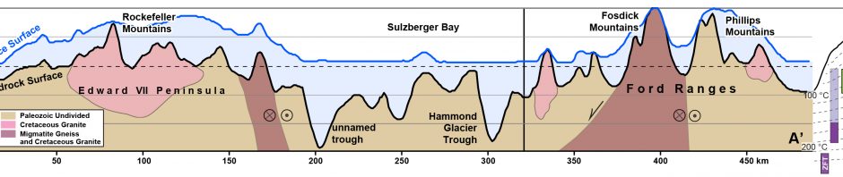
2010-2014 Collaborative Research: Polyphase orogenesis and crustal differentiation in West Antarctica, with Mike Brown, U. Maryland. NSF- OPP-0944600.
The research examines the geological processes that transformed a voluminous succession of marine turbidites intruded into differentiated continental crust along the margin of Gondwana. The northern Ford ranges in Marie Byrd Land, Antarctica, are the focus of the integrated program of fieldwork, structural geology, petrology, mineral equilibria modeling, geochronology and geochemistry that examines the roles of high temperature metamorphism, melting, and deformation in the maturation of continental crust.
2010-2013 Research at Undergraduate Institutions: Development of an on-line GIS repository of geological data from the Ford Ranges, Marie Byrd Land, and application to Cenozoic paleogeography reconstruction, NSF-OPP-0944777.
This work integrated new, high resolution satellite imagery with a new GIS-based repository of geological data sets from West Antarctica. It provides undergraduates with an exciting context in which to acquire fundamental skills and analytical experience in GIS together with an understanding of physical-chemical principles. Training is supported by the Keck GIS Learning Commons at Colorado College and the Polar Geospatial Information Center at University of Minnesota. The students’ research involved use of GIS for inquiry and interpretation of a geological-glacial setting that has significance for climate, ice sheet, and tectonic evolution of West Antarctica. The compilations of on-line geological data and bedrock physical parameters is a resource for quantitative analysis of past paleotopography by the international ANTscape initiative (ANTscape.org).
2009-2013 Collaborative Research: Formation of basement-involved foreland arches: An Integrated structural and seismic EarthScope experiment. With M. Anderson (Colorado College), E. Erslev (U. Wyoming), Anne Sheehan (CU-Boulder), and Kate Miller (UTEP), NSF-EAR-0843889.
This collaborative project involved integrated seismology and structural geology research in the Bighorn Mountains range of Wyoming. The research is funded by NSF Earthscope (www.earthscope.org), a multi-year initiative to explore the structure and evolution of the North American continent. Generally speaking, Earthscope seeks to determine the continent’s configuration at the scale of the lithosphere, using diverse “remote sensing” techniques from geophysics. The Bighorns range is an optimal place to use seismology and structural geology to construct three-dimensional images of the North American lithosphere, at vastly greater scale but analogous to computed tomography (CT) or magnetic resonance imaging (MRI) models that are used in human medicine. The Bighorn Mountains form an vast structural arch that is an internationally known example of deformation in the interior of a tectonic plate, far from a plate boundary, and as such it offers extraordinary opportunities for this innovative research.
The project is a collaboration with investigators from three institutions in addition to CC. These are Colorado State University, University of Texas – El Paso, and the University of Colorado – Boulder. The field and laboratory studies will involve up to ten undergraduates from Colorado College over the three years of the project. The students will work closely together with the team of faculty and graduate researchers and undertake original investigations in seismology and structural geology that contribute to the overall aims of the project.
1997-2002 Collaborative Research: Air-Ground Study of Tectonics at the Boundary Between the Eastern Ross Embayment and Western Marie Byrd Land, Antarctica: Basement Geology and Structure. Award OPP-9615282, Co-PIs: Christine Siddoway Bruce Luyendyk (UCSB).
Combined airborne geophysics and brittle fault studies have determined the crustal structure and kinematic history of the eastern Ross Sea margin in western Marie Byrd Land (MBL). Range-and-glacier topography at ~20 km spacing coincides with extended crust ~25 km thick determined from gravity modeling. Brittle faults and mafic dikes provide the first kinematic data for the region and record extension directed ~N70E at circa 105 to 95 Ma when most of the extension occurred. The finding is contrary to the prevailing view that ~N-S stretching, orthogonal to the rifted margin, was in effect at this time. An hypothesis that reconciles kinematic information from the regional brittle structures with the strain history of a localized exposure of middle crust (Fosdick migmatite dome) is for regional transcurrent strain induced by dextral oblique convergence between the Phoenix and Gondwana plates in Early Cretaceous time (Siddoway, 2004). We infer that ultimate breakup between MBL and New Zealand-Campbell Plateau occurred upon the transcurrent structures, and note that structural control by preexisting wrench structures accounts for breakup across the Ross Sea basin trends; the paucity of evidence for fault activity on land during 67 Ma breakup; and the rapid development of new plate boundaries without widespread deformation of adjoining crustal blocks. Six publications (Siddoway et al., 2004a, b, 2005; Siddoway, 2008; Luyendyk et al., 2003; Stone et al., 2003) resulted from this work. Three undergraduate colleagues contributed to collection and interpretation of the kinematic dataset (Whitehead, 1999; Sass, 2000; and Cowdery, 2001). Geochemical investigation of Pleistocene basalts makes part of one doctoral thesis (Gaffney and Siddoway, 2004).
2000-2003 Collaborative Research: Contrasting Styles of Ca. 1.4 Ga Tectonism in the Southern Rockies: Evidence for a Fossil Rheologic Transition in a Deeply Exhumed Intracontinental Orogen. EAR-0101314, Co-PIs: K.Karlstrom, M.Williams, J. Connelly, C. Siddoway
Research in the Wet Mountains of Colorado focuses upon deeply exhumed Mesoproterozoic gneisses in a region hypothesized to have supported an intracontinental plateau developed during circa 1.4 Ga transpression along the southern boundary of Laurentia. The Wet Mountains expose a transition between partitioned strain, with deformation localized upon shear zones bounding coherent crustal blocks, and melt-dominated behavior supporting penetrative flow within migmatites. Potentially these ancient rocks provide an analog for the partial-melt horizon documented in contemporary orogenic plateaus, such as the Tibetan Plateau. Eight AGU and GSA abstracts and one field guide contribution result from this work (e.g. Leonard et al. 2002; Siddoway et al., 2002, 2001; Andronicos et al., 2002, 2001; Dean et al., 2002, 2001). https://www.fastlane.nsf.gov/servlet/showaward?award=0101314
1997 Collaborative International Research: Investigation of Structures, Structural Fabrics and Metamorphic Associations in Northern Victoria Land, NSF-OPP 9702161 https://www.fastlane.nsf.gov/servlet/showaward?award=9702161
The objective of the field investigation was to obtain detailed structural, petrographic, isotopic, and geochronological information that bears on the history of early Paleozoic magmatism in northern Victoria Land (NVL), arising from plate convergence during the Ross Orogeny.