Bedrock exposures are comparatively sparse in Marie Byrd Land, but they provide important constraints on the geological evolution and glacial history of West Antarctica. We prepared the first digital geological map for Marie Byrd Land using ground-based geological data, gathered from firsthand observations, published literature, and legacy map data. Also mapped are supraglacial features, seasonal water and blue ice, through use of 1:250 000 USGS maps and features identified in satellite imagery via the Landsat Image Mosaic of Antarctica and DigitalGlobe derivative products held by the Polar Geospatial Center. The Digital Geological Map of Marie Byrd Land is a component of SCAR GeoMap, a continent-scale compilation with spatial accuracy of ±250 m. Feature classification is according to international GeoSciML data format. Recent conference presentations of the completed dataset are here [Millikin et al. 2017; Siddoway et al. 2018]; a recent GeoMap update is here.
The most extensive outcrops in Marie Byrd Land are found in the Ford Ranges and Edward VII Peninsula, bordering the Ross Sea and Ice Shelf. The completed western Marie Byrd Land map covers an on-continent coastal area of 135,000 km2 between 140°E to 160°E and from 75°S to 80°S. The resolvable scale is 1:250 000 or better. Exposed rock is delimited by 911 polygons, occupying 250 km2 that comprises 0.2% of the total area. The geology consists of Early Paleozoic metaturbidites intruded by mid-Paleozoic and late Mesozoic granitoids, with migmatite-granite associations exposed in the footwall of detachment faults. Meager volcanic exposures contain abundant ultramafic xenoliths. The map of central and eastern Marie Byrd Land and Ellsworth Mountains is also completed. Exposed rock is delimited by 3560 polygons.
Supraglacial features, glacial till and hyaloclastite, together with seasonal water and blue ice, are distinguished within the digital map due to their relevance to ice sheet history and dynamics. In western Marie Byrd Land, there are 119 mapped till deposit polygons (11.2 km2), 58 supraglacial tills (5.7 km2) and 69 seasonal water features (21.5 km2) that provide a baseline for past and future glaciological change.
Rendered in geographic information system software Esri© ArcMap, the GIS is available as GoogleEarth .kmz files. To request the kmz or map Legend, contact csiddoway AT coloradocollege.edu.
Map compilation completed with contributions from:
Lexie Millikin, Sam Elkind, Tristan White, Merril Stypula, Alexandra Freeman, Maggie Cowling, Rose Vail Bloom, Simon C. Cox, Brad Herried, and Noah Villamarin-Cutter. Facilities and technological support: GIS Lab – Colorado College, Polar Geospatial Center, and GNS Science. Ground-based geological mapping was supported by NSF-OPP-9615282, 0944777, 0338279; NSF-AES-944600; and NSF-AISS-1443497.
Western Marie Byrd Land GeoMap sources
Gaffney, Amy M. and Siddoway C.S., 2007, Heterogeneous sources for Pleistocene lavas of Marie Byrd Land, Antarctica: new data from the SW Pacific diffuse alkaline magmatic province. In: Cooper, A.K. et al., U.S. Geological Survey, USGS OFR-2007-1047, http://pubs.usgs.gov/of/2007/1047/ea/of2007-1047ea063.pdf.
Luyendyk, B. P., Wilson, D. and Siddoway, C.S., 2003, The eastern margin of the Ross Sea Rift in western Marie Byrd Land: Crustal structure and tectonic development: Geochemistry, Geophysics, Geosystems (G3), v. 4 (10), 1090, doi:10.1029/2002GC000462.
Siddoway, C.S., Sass, L.C. III, Esser, R.P., 2005, Kinematic history of the Marie Byrd Land terrane, West Antarctica: Direct evidence from Cretaceous mafic dykes, in Vaughan, A., Leat, P., and Pankhurst, R.J. (eds.), Terrane Processes at the Margin of Gondwana, Geological Society of London, Special Publication 246, p. 417-438.
Siddoway, C., 2008, Tectonics of the West Antarctic rift system: New light on the history and dynamics of distributed intracontinental extension (invited paper) in Cooper, A.K. et al., Antarctica: A Keystone in a Changing World, National Academy of Sciences, Washington, D.C., pp. 91-114. http://pubs.usgs.gov/of/2007/1047/kp/kp09/index.html.
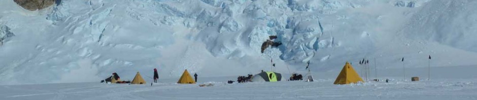
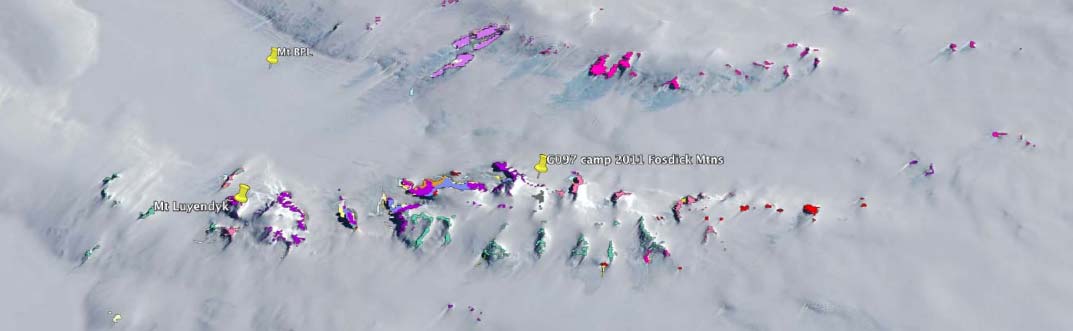
Siddoway, C., 1990 – 2012, firsthand observation and mapping (2 seasons in northern Ford Ranges, 1 season in Edward VII Peninsula, 2 seasons in southern Ford Ranges, and 4 seasons in Fosdick Mountains).
Wade, F.A., C.A. Cathey, and J.B. Oldham, Reconnaissance geologic map of the Guest Peninsula quadrangle, Marie Byrd Land, Antarctica, Map A-7, U. S. Antarctic Research Program, Reston, VA, 1977a.
Wade, F.A., C.A. Cathey, and J.B. Oldham, Reconnaissance geologic map of the Boyd Glacier quadrangle, Marie Byrd Land, Antarctica, Map A-6., U. S. Antarctic Research Program, Reston, VA, 1977b.
Wade, F.A., C.A. Cathey, and J.B. Oldham, Reconnaissance geologic map of the Alexandra Mountains quadrangle, Marie Byrd Land, Antarctica, Map A-5, U. S. Antarctic Research Program, Reston, VA, 1977c.
Wade, F.A., C.A. Cathey, and J.B. Oldham, Reconnaissance geologic map of the Gutenko Nunataks quadrangle, Marie Byrd Land, Antarctica, Map A-11, 1978.
Weaver, S.D., J.D. Bradshaw, and C.J. Adams, Granitoids of the Ford Ranges, Marie Byrd Land, Antarctica, in Geological Evolution of Antarctica, edited by M.R.A. Thompson, et al., pp. 345-351, Cambridge Univ. Press, Cambridge, Mass., 1991.
Central and Eastern Marie Byrd Land // Thurston Island GeoMap sources
Brand, J. F. (1979): Low grade metamorphic rocks of the Ruppert and Hobbs coasts of Marie Byrd Land, Antarctica (https://ttu-ir.tdl.org/ttu-ir/handle/2346/9123.
Gohl, K. (2011): Basement control on past ice sheet dynamics in the Amundsen Sea Embayment, West Antarctica.- Palaeogeography, Palaeoclimatology, Palaeoecology, doi:10.1016/j.palaeo.2011.02.022.
Hart, S.R., Blusztajn, J., and Craddock, C. (1995): Cenozoic volcanism in Antarctica: Jones mountains and Peter I island – Geochimica et Cosmochimica Acta, 59 (16): 3379-3388.
Hole, M.J., Storey, B.C., and LeMasurier, W.E. (1994): Tectonic setting and geochemistry of Miocene alkali basalts from the Jones Mountains, West Antarctica- Antarctic Science, 6 (1): 85-92.
Kipf, A., Hauff, F. , Werner, R. , Gohl, K. , van den Bogaard, P. , Hoernle, K. , Maicher, D. and Klügel, A. (2014): Seamounts off the West Antarctic margin: A case for non-hotspot driven intraplate volcanism. Gondwana Research, 25 (4): 1660-1679 . doi:10.1016/j.gr.2013.06.013 , hdl:10013/epic.42470
Leat, P.T., Storey, B.C. and Pankhurst, R.J. (1993): Geochemistry of Palaeozoic–Mesozoic Pacific Rim orogenic magmatism, Thurston Island area, West Antarctica.- Antarctic Science, 5: 281-296, doi: 10.1017/S0954102093000380.
LeMasurier, W.E. (1984): Mount Siple volcano, Marie Byrd Land.-Antarctic Journal: 33-35.
LeMasurier, W.E. (2013): Shield volcanoes of Marie Byrd Land, West Antarctic rift: Oceanic island similarities, continental signature, and tectonic controls.- Bulletin of Volcanology, Wesley E. Lemasurier
Le Masurier, W. E., 2002, Architecture and evolution of hydrovolcanic deltas in Marie Byrd Land, Antarctica, Geological Society, London, Special Publications 2002, v. 202, p. 115-148.
LeMasurier, W.E. and Rex, D.C. (1989): Evolution of linear volcanic ranges in Marie Byrd Land, West Antarctica, Journal of Geophysical Research, B, Solid Earth and Planets, 94: 7223-7236.
LeMasurier, W.E., and Thomson, J.W. (1990): Volcanoes of the Antarctic Plate and Southern Oceans.-Antarctic Research Series, 48: 150-255.
LeMasurier, W.E., Harwood, D.M. and Rex, D. C. (1994): Geology of Mount Murphy Volcano: An 8-m.y. history of interaction between a rift volcano and the West Antarctic ice sheet.- Geological Society of America Bulletin, 106(2): 265-280: 10.1130/0016-7606(1994)106<0265:GOMMVA>2.3.CO;2.
LeMasurier, W.E., and Rocchi, S. (2005): Terrestrial record of post-Eocene climate history in Marie Byrd Land, West Antarctica: Geografiska Annaler, 87A: 1–16.
LeMasurier, W.E., Choi, S. H., Hart, S.R., Mukasa, S., and Rogers, N. (2016): Reconciling the shadow of a subduction signature with rift geochemistry and tectonic environment in Eastern Marie Byrd Land, Antarctica.-Lithos 260: 134-153, doi: 10.1016/j.lithos.2016.05.018.
Metcalfe, A.P., Sporli, K.B., and Craddock, C. (1978): Plutonic rocks from the Ruppert Coast, West Antarctica: Antarctic Journal: 5-7.
Mukasa, S.B. and Dalziel, I.W.D. (2000): Marie Byrd Land, West Antarctica.- Evolution of Gondwana’s Pacific margin constrained by zircon U-Pb geochronology and feldspar common-Pb isotopic compositions.- Geological Society of America Bulletin, 112: 611-627.
Pankhurst, R.J., Millar, I. L., Grunow, A. M. and Storey, B. C. (1993): The Pre-Cenozoic Magmatic History of the Thurston Island Crustal Block, West Antarctica,- Journal of Geophysical Research, 98 (B7): 11835–11849, doi:10.1029/93JB01157.
Pankhurst, R.J., Weaver, S. D., Bradshaw, J. D., Storey, B. C. and Ireland, T. R. (1998): Geochronology and geochemistry of pre-Jurassic superterranes in Marie Byrd Land, Antarctica.- Journal of Geophysical Research, 103 (B7): 2529-2547.
Panter, K.S., McIntosh, W.C. & Smellie, J.L. (1994): Volcanic history of Mount Sidley, A major alkaline volcano in Marie Byrd Land, Antarctica.- Bulletin of Volcanology, 56, 361–376, doi:10.1007/BF00326462.
Prestvik, T. and Duncan, R.A., (1991): The Geology and Age of Peter Island, Antarctica- Polar Research, 9 (1): 89-98.
Riley, T., Flowerdew, M., Pankhurst, R. J., Leat, T., Millar, I., Fanning, C.M. and Whitehouse, M. (2016): A revised geochronology of Thurston Island, West Antarctica and correlations along the proto-Pacific margin of Gondwana.- Antarctic Science, doi: http://dx.doi.org/10.1017/S0954102016000341.
Spiegel, C., Lindow, J., Kamp, P.J.J., Meisel, O., Mukasa, S., Lisker, F., Kuhn, G. and Gohl, K. (2016): Tectonomorphic evolution of Marie Byrd Land – Implications for Cenozoic rifting activity and onset of West Antarctic glaciation.- Global and Planetary Change, in press.
Wilch, T.I., and McIntosh, W.C. (2000): Eocene and Oligocene volcanism at Mount Petras, Marie Byrd Land: Implications for middle Cenozoic ice sheet reconstructions in West Antarctica.-Antarctic Science 12 (4): 477-491.
Wilch, T.I., and McIntosh, W.C. (2007): Miocene-Pliocene Ice-Volcano Interactions at Monogenetic Volcanoes Near Hobbs Coast, Marie Byrd Land, Antarctica, in Antarctica: A Keyston in a Changing World- Online Proceedings of the 10th ISAES, edited by A. K> Cooper and C.R. Raymond, USGS Open-File Report 2007-1047, Short Research Paper 074, doi: 10.3133/of2007-1047.srp074 .
Wilch, T.I., and McIntosh, W.C. (2002): Lithofacies analysis and 40Ar/39Ar geochronology of ice-volcano interactions at Mt. Murphy and the Crary Mountains, Marie Byrd Land, Antarctica, Geological Society, London, Special Publications 2002, v. 202, p. 237-253.
Veevers, J.J. and Saeed, A. (2013): Age and composition of Antarctic sub-glacial bedrock reflected by detrital zircons, erratics, and recycled microfossils in the Ellsworth Land–Antarctic Peninsula–Weddell Sea–Dronning Maud Land sector (240°E–0°–015°E) Gondwana Research, 23 (1): 296-332.
Wade, F. A. (1969): Geologic Map of Antarctica Sheet 18, Marie Byrd Land, Folio 12 – Geology, American Geographical Society, scale 1: 1 000 000.